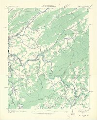
1935 Map of Butler
USGS Topo · Published 1935About this map
Butler serves as a primary hub along the Watauga River in this 1935 survey, a period just before the landscape was fundamentally altered by Tennessee Valley Authority projects. The map documents a deeply established mountain community structured around river forks and creek bottoms, featuring significant educational and spiritual landmarks like the Watauga Academy and Saint Valley Sch. Industrial and logistical details are prominent, including the Lupperts Flume Bridge and several gauging stations that hint at the era's focus on water management and timber transport. Numerous family-named settlements like Cownstown and Buntontown are connected by a network of trails and early state roads. The terrain is defined by prominent ridges such as Sink Mountain and Beech Mountain, while smaller hollows like Sugar Hollow and Sheets Hollow provide a glimpse into the localized geography where small-scale farming and residence occurred before widespread topographical changes.
Find a feature on this map
100 named features on this map. Tap any name to fly to it.
Don’t see what you’re looking for? This feature index may not catch every label — zoom into the map to look around manually.
Map Details
Editions of this 1935 Butler Map
2 editions found
Other maps of this area

1891 · Roan Mountain
USGS Topo · 1:125,000

1893 · Cranberry
USGS Topo · 1:125,000

1894 · Roan Mountain
USGS Topo · 1:125,000

1895 · Cranberry
USGS Topo · 1:125,000

1899 · Cranberry
USGS Topo · 1:125,000

1902 · Cranberry
USGS Topo · 1:125,000

1904 · Roan Mountain
USGS Topo · 1:125,000

1934 · Valle Crucis
USGS Topo · 1:24,000

1934 · White Rocks Mtn
USGS Topo · 1:24,000

1934 · Elk Park
USGS Topo · 1:24,000