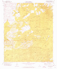
1971 Map of Butler Peak
USGS Topo · Published 1975About this map
The high backcountry of the San Bernardino National Forest is defined here by a network of seasonal springs and small-scale mining operations. Remote sites like the Balanced Rock Mine and Liberty Mine are tucked into the drainages of Coyote Flat and White Mountain, reached by a web of jeep trails. The landscape reflects a mid-century era of recreational development, with organized sites such as the Lake Arrowhead Scout Camp and the Big Pine Flat Campground established alongside historic homesteading remnants like Hawes Ranch. Water management is central to the area's utility, marked by dozens of named water sources including Jackrabbit Spring and Chipmunk Spring. High-elevation landmarks like Butler Peak and Crafts Peak anchor the topography, while the Pacific Crest National Scenic Trail winds through the southern ridges.
Find a feature on this map
78 named features on this map. Tap any name to fly to it.
Don’t see what you’re looking for? This feature index may not catch every label — zoom into the map to look around manually.
Map Details
Editions of this 1971 Butler Peak Map
2 editions found
Other maps of this area

1899 · Redlands
USGS Topo · 1:62,500

1901 · Southern California Sheet No. 1
USGS Topo · 1:250,000

1901 · Redlands
USGS Topo · 1:62,500

1902 · Deep Creek
USGS Topo · 1:62,500

1902 · San Gorgonio
USGS Topo · 1:125,000

1904 · Southern California Sheet No. 1
USGS Topo · 1:250,000

1947 · Lucerne Valley
USGS Topo · 1:62,500

1949 · Lucerne Valley
USGS Topo · 1:62,500

1953 · San Bernardino
USGS Topo · 1:250,000
1953 · Harrison Mtn.
USGS Topo · 1:24,000