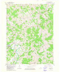
1981 Map of Butler
USGS Topo · Published 1982About this map
The Licking River winds deeply through the heart of this Pendleton County landscape, where the town of Butler serves as a primary hub. This 1981 revision documents a rural community defined by its watercourses and ridges, featuring several small settlements like Mt Auburn, Peach Grove, and Kohler. Transportation follows the river valley, most notably the Louisville and Nashville railroad which parallels the water through the western portion of the quadrangle. Genealogists will find a wealth of local landmarks, from family-named cemeteries such as Fisher Cem and Norris Cem to community anchors like Wesley Chapel and Northern Sch. The terrain is marked by numerous creeks including Twelvemile Creek, Flour Creek, and Stepstone Creek, which carved the steep valleys that shaped local road patterns and land use into the late twentieth century.
Find a feature on this map
36 named features on this map. Tap any name to fly to it.
Don’t see what you’re looking for? This feature index may not catch every label — zoom into the map to look around manually.
Map Details
Editions of this 1981 Butler Map
This is the sole edition of this map. No revisions or reprints were ever made.
Other maps of this area

1929 · Alexandria
USGS Topo · 1:48,000

1930 · Falmouth
USGS Topo · 1:48,000

1931 · Felicity
USGS Topo · 1:62,500

1936 · Alexandria
USGS Topo · 1:62,500

1936 · Falmouth
USGS Topo · 1:62,500

1952 · Berlin
USGS Topo · 1:24,000

1953 · Laurel
USGS Topo · 1:24,000

1953 · Butler
USGS Topo · 1:24,000

1953 · New Richmond
USGS Topo · 1:24,000
1953 · De Mossville
USGS Topo · 1:24,000