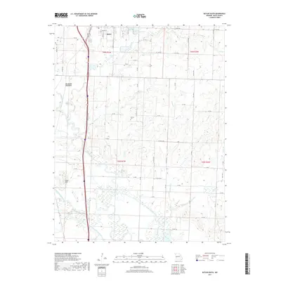
2017 Map of Butler South
USGS Topo · Published 2017About this map
The southern outskirts of Butler and the rural townships of Bates County are defined by an extensive network of managed waterways and low-lying river bottoms. The landscape is marked by the meandering path of the Marais des Cygnes River, which creates distinctive geographical features like Negro Bend. To manage the seasonal flow through these plains, a complex system of channels including the Miami Drainage Ditch and the Bates County Drainage Ditch has been established, illustrating the region's long-term commitment to agricultural drainage and land reclamation.
Find a feature on this map
70 named features on this map. Tap any name to fly to it.
Don’t see what you’re looking for? This feature index may not catch every label — zoom into the map to look around manually.
Map Details
Editions of this 2017 Butler South Map
This is the sole edition of this map. No revisions or reprints were ever made.
Other maps of this area

1887 · Butler
USGS Topo · 1:125,000

1894 · Butler
USGS Topo · 1:125,000

1934 · Papinsville
USGS Topo · 1:24,000

1936 · Rich Hill
USGS Topo · 1:24,000

1937 · New Home
USGS Topo · 1:24,000
1942 · Sprague
USGS Topo · 1:24,000

1947 · Lawrence
USGS Topo · 1:250,000

1950 · Lawrence
USGS Topo · 1:250,000
1955 · Rich Hill
USGS Topo · 1:24,000

1956 · Lawrence
USGS Topo · 1:250,000