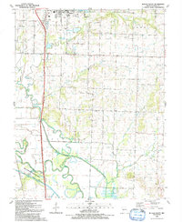
1991 Map of Butler South
USGS Topo · Published 1991About this map
The Marais des Cygnes River meanders through the southern reaches of this Bates County landscape, defining the transition between the rolling uplands of Mt Pleasant and the broad alluvial plains. Just south of the city of Butler, the terrain is characterized by a managed hydraulic environment where the river's path is regulated by extensive levee systems. This area serves as a significant recreational and utility hub, featuring Butler Recreational Lake, Kentucky Lake, and the Old Town State Access Area. Local landmarks such as the Fairview Cem and Mt Zion Ch provide essential touchpoints for genealogists tracing family histories in the rural townships of Lone Oak and Summit. The map also documents the industrial presence of Oil Wells scattered near the settlement of Peru, reflecting the region's diverse economic activities at the start of the 1990s.
Find a feature on this map
29 named features on this map. Tap any name to fly to it.
Don’t see what you’re looking for? This feature index may not catch every label — zoom into the map to look around manually.
Map Details
Editions of this 1991 Butler South Map
This is the sole edition of this map. No revisions or reprints were ever made.
Other maps of this area

1887 · Butler
USGS Topo · 1:125,000

1894 · Butler
USGS Topo · 1:125,000

1934 · Papinsville
USGS Topo · 1:24,000

1936 · Rich Hill
USGS Topo · 1:24,000

1937 · New Home
USGS Topo · 1:24,000
1942 · Sprague
USGS Topo · 1:24,000

1947 · Lawrence
USGS Topo · 1:250,000

1950 · Lawrence
USGS Topo · 1:250,000
1955 · Rich Hill
USGS Topo · 1:24,000

1956 · Lawrence
USGS Topo · 1:250,000