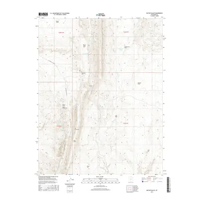
2017 Map of Butler Valley
USGS Topo · Published 2017About this map
Grosvenor Arch stands as a primary landmark in this southern Utah landscape, where the high desert terrain is defined by dramatic geological formations and deep drainages. The map centers on the transition between the Butler Valley and the striking linear ridge of The Cockscomb, a prominent monocline that dictates the local hydrology. Water sources are scarce but significant, marked by the Butler Valley Reservoir and the Headquarters Springs in the northern reaches of Headquarters Valley. These features, alongside ephemeral waterways like Cottonwood Cr and Wahweap Cr, illustrate the challenges of land use in this arid region. The presence of Cottonwood Canyon Rd provides the primary corridor through these valleys, linking several open flats such as Horse Flat and Long Flat within a territory largely shaped by the erosive forces seen at The Gut and Blue Wash.
Find a feature on this map
22 named features on this map. Tap any name to fly to it.
Don’t see what you’re looking for? This feature index may not catch every label — zoom into the map to look around manually.
Map Details
Editions of this 2017 Butler Valley Map
This is the sole edition of this map. No revisions or reprints were ever made.
Other maps of this area

1886 · Escalante
USGS Topo · 1:250,000

1922 · Upper Last Chance
USGS Topo · 1:63,360

1955 · The Cockscob SW
USGS Topo · 1:24,000

1956 · Escalante
USGS Topo · 1:250,000

1960 · Escalante
USGS Topo · 1:250,000

1964 · Horse Flat
USGS Topo · 1:24,000

1964 · Canaan Peak
USGS Topo · 1:24,000

1964 · Death Ridge
USGS Topo · 1:24,000

1964 · Henrieville
USGS Topo · 1:24,000
1964 · Calico Peak
USGS Topo · 1:24,000