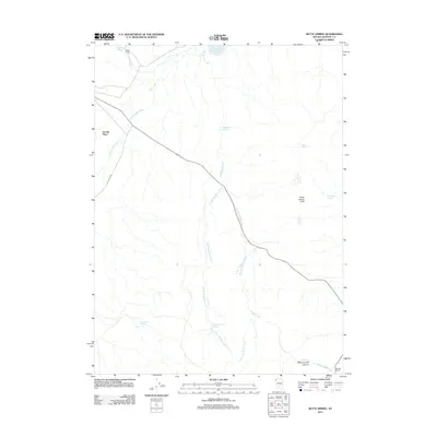
2011 Map of Butte Spring
USGS Topo · Published 2011About this map
Swedes Place and Swingle Ranch stand as isolated outposts in this high-desert landscape of Washoe County, where water management is the primary marker of human presence. The 2011 survey reveals an intricate network of drainage and catchment systems, notably the Little Hog Ranch Reservoir and Hog John Reservoir, which collect seasonal runoff from the surrounding uplands. These reservoirs, along with numerous named seeps like Bath Tub Spring and Denio Camp Springs, were critical for sustaining livestock in an area where permanent water is scarce. The geography is defined by the branching tributaries of Big Hog Ranch Creek and the dramatic relief of Willow Creek Canyon in the southeast. This map documents a remote ranching frontier where life follows the paths of intermittent streams like Cottonwood Creek and the lone transit route of Lost Creek Rd.
Find a feature on this map
19 named features on this map. Tap any name to fly to it.
Don’t see what you’re looking for? This feature index may not catch every label — zoom into the map to look around manually.
Map Details
Editions of this 2011 Butte Spring Map
This is the sole edition of this map. No revisions or reprints were ever made.
Other maps of this area

1889 · Long Valley
USGS Topo · 1:250,000

1954 · Vya
USGS Topo · 1:250,000

1958 · Vya
USGS Topo · 1:250,000

1962 · Vya
USGS Topo · 1:250,000

1972 · Mahogany Mtn
USGS Topo · 1:24,000

1972 · High Rock Lake
USGS Topo · 1:24,000

1978 · Hart Mountain
USGS Topo · 1:24,000

1979 · Butte Spring
USGS Topo · 1:24,000
1979 · Chester Lyons Spring
USGS Topo · 1:24,000
1980 · Fox Mountain
USGS Topo · 1:24,000