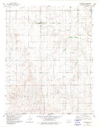
1980 Map of Buttermilk
USGS Topo · Published 1980About this map
Buttermilk sits at a geographic and historical crossroads in southern Kansas, where the prairie landscape is divided by the Old Indian Treaty Boundary. This 1980 survey captures the remote character of the region as it transitions across the Kansas Oklahoma state line and the border between Comanche and Woods Counties. The drainage of the Salt Fork Arkansas River and its tributaries, including West Creek and Sheele Creek, defines the local topography, which is largely given over to ranching and resource extraction. Evidence of local community life persists at Antioch Ch, while industrial activity is noted by scattered Gravel Pits and a Drill Hole. The presence of a prominent Water Tank and the persistent label of Villa across the central plains suggest the enduring markers of this sparsely populated borderland.
Find a feature on this map
12 named features on this map. Tap any name to fly to it.
Don’t see what you’re looking for? This feature index may not catch every label — zoom into the map to look around manually.
Map Details
Editions of this 1980 Buttermilk Map
This is the sole edition of this map. No revisions or reprints were ever made.
Other maps of this area

1892 · Coldwater
USGS Topo · 1:125,000

1955 · Woodward
USGS Topo · 1:250,000

1955 · Pratt
USGS Topo · 1:250,000

1958 · Woodward
USGS Topo · 1:250,000

1959 · Pratt
USGS Topo · 1:250,000

1970 · Lookout
USGS Topo · 1:24,000

1970 · Freedom NW
USGS Topo · 1:24,000

1970 · Selman NW
USGS Topo · 1:24,000

1979 · Protection NE
USGS Topo · 1:24,000
1979 · Nescatunga Creek South
USGS Topo · 1:24,000