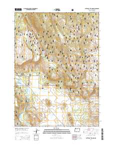
2014 Map of Buttes of the Gods
USGS Topo · Published 2014About this map
Winema National Forest dominates this section of Klamath County, where volcanic topography and water management define the landscape. The northern half of the survey is marked by a series of irrigation and water storage sites, including Prairie Reservoir, Wigwam Reservoir, and John Smith Reservoir. These features speak to the region's historical reliance on managed water resources within the high-desert environment. The central and southern portions are characterized by a striking cluster of volcanic peaks, most notably the Buttes of the Gods, along with Wolf Butte, Coyote Butte, and Antone Butte.
Find a feature on this map
65 named features on this map. Tap any name to fly to it.
Don’t see what you’re looking for? This feature index may not catch every label — zoom into the map to look around manually.
Map Details
Editions of this 2014 Buttes of the Gods Map
This is the sole edition of this map. No revisions or reprints were ever made.
Other maps of this area

1889 · Klamath
USGS Topo · 1:250,000

1894 · Klamath
USGS Topo · 1:250,000

1955 · Klamath Falls
USGS Topo · 1:250,000

1956 · Calimus Butte
USGS Topo · 1:62,500

1957 · Swan Lake
USGS Topo · 1:62,500

1958 · Klamath Falls
USGS Topo · 1:250,000

1960 · Beatty
USGS Topo · 1:62,500

1960 · Fuego Mountain
USGS Topo · 1:62,500

1980 · Williamson River
USGS Topo · 1:100,000
1985 · Sprague River West
USGS Topo · 1:24,000