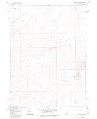
1980 Map of Button Lake
USGS Topo · Published 1980About this map
Evans Lake and the high-desert basins of the Nevada interior are documented in this 1980 survey, showing the remote borderlands where Humboldt Co and Elko Co meet. The landscape is defined by its isolation and utility, featuring a long Pipeline that cuts across the northern reaches and a solitary Landing Strip situated among the contours of the high country. An Indefinite Boundary marks the eastern edge of the quadrangle near the shores of Button Lake, suggesting the challenges of surveying this complex terrain. Movement through the area is restricted to a network of Jeep Trails, which provide the only access to the seasonal water features like the simple Lake and Creek at the southern end of the sheet. This map serves as a detailed record of land use and geography in a sparsely populated region of the Great Basin.
Find a feature on this map
9 named features on this map. Tap any name to fly to it.
Don’t see what you’re looking for? This feature index may not catch every label — zoom into the map to look around manually.
Map Details
Editions of this 1980 Button Lake Map
This is the sole edition of this map. No revisions or reprints were ever made.
Other maps of this area

1882 · Paradise
USGS Topo · 1:250,000

1893 · Paradise
USGS Topo · 1:250,000

1955 · McDermitt
USGS Topo · 1:250,000

1959 · McDermitt
USGS Topo · 1:250,000

1973 · Star Valley Ridge SW
USGS Topo · 1:24,000

1973 · Button Lake Well
USGS Topo · 1:24,000

1973 · Humboldt Hill
USGS Topo · 1:24,000

1980 · Greeley Flat
USGS Topo · 1:24,000
1980 · Maiden Butte
USGS Topo · 1:24,000
1980 · Greeley Flat SE
USGS Topo · 1:24,000