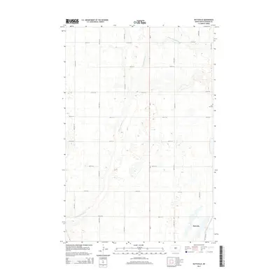
2014 Map of Buttzville
USGS Topo · Published 2014About this map
Buttzville sits at the southern edge of this Ransom County landscape, serving as a focal point in a region defined by agricultural plots and the wandering path of the S Branch Maple River. The terrain is marked by a rigorous section-line grid of rural routes, including ND-32 and various local avenues such as 128th Ave SE and 133rd Ave SE. These roads segment the prairie into large rectangular tracts characteristic of North Dakota's farming heritage. Near the eastern border, Saint Olaf Cem provides a specific point of interest for genealogists and local historians, representing the longstanding community roots in Moore Township. The geography here is largely open, with the river's various branches and small depressions creating the only significant breaks in the geometric road network.
Find a feature on this map
18 named features on this map. Tap any name to fly to it.
Don’t see what you’re looking for? This feature index may not catch every label — zoom into the map to look around manually.
Map Details
Editions of this 2014 Buttzville Map
This is the sole edition of this map. No revisions or reprints were ever made.
Other maps of this area

1897 · Tower
USGS Topo · 1:125,000

1953 · Fargo
USGS Topo · 1:250,000

1956 · Fargo
USGS Topo · 1:250,000

1960 · Lisbon NE
USGS Topo · 1:24,000

1960 · Enderlin South
USGS Topo · 1:24,000

1961 · Enderlin North
USGS Topo · 1:24,000

1962 · Lisbon
USGS Topo · 1:24,000

1962 · Elliott
USGS Topo · 1:24,000

1965 · Lucca
USGS Topo · 1:24,000
1967 · Nome SE
USGS Topo · 1:24,000