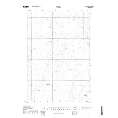
2020 Map of Buttzville
USGS Topo · Published 2020About this map
Buttzville sits in the southeast corner of this rural Ransom County landscape, serving as a primary point of reference in Moore Township. The terrain is defined by the winding course of the S Br Maple River, also labeled as the South Branch Maple River, which meanders through the central and western sections of the map. This modern survey illustrates the enduring agricultural grid of North Dakota, where section lines are strictly maintained by a network of local roads such as 130th Ave SE and 60th St SE. For genealogists and local historians, the Saint Olaf Cem on the eastern edge of the quadrangle provides a specific link to the community's heritage. The map also traces the path of Co Hwy 135 as it cuts across the southwestern corner, reflecting the region's connectivity to the broader state highway system.
Find a feature on this map
24 named features on this map. Tap any name to fly to it.
Don’t see what you’re looking for? This feature index may not catch every label — zoom into the map to look around manually.
Map Details
Editions of this 2020 Buttzville Map
This is the sole edition of this map. No revisions or reprints were ever made.
Other maps of this area

1897 · Tower
USGS Topo · 1:125,000

1953 · Fargo
USGS Topo · 1:250,000

1956 · Fargo
USGS Topo · 1:250,000

1960 · Lisbon NE
USGS Topo · 1:24,000

1960 · Enderlin South
USGS Topo · 1:24,000

1961 · Enderlin North
USGS Topo · 1:24,000

1962 · Lisbon
USGS Topo · 1:24,000

1962 · Elliott
USGS Topo · 1:24,000

1965 · Lucca
USGS Topo · 1:24,000
1967 · Nome SE
USGS Topo · 1:24,000