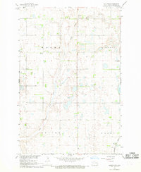
1967 Map of Buttzville
USGS Topo · Published 1969About this map
The Maple River and its South Branch Maple River meander through this Ransom County landscape, defining the topography of the central North Dakota plains in the late 1960s. The village of Buttzville serves as a focal point in the southeast, situated along the tracks of the Northern Pacific railroad. This area is divided into several rural townships including Moore, Liberty, Tuller, and Casey, each reflecting the organized settlement patterns of the region. Scattered throughout the townships are localized landmarks such as a rural Townhall and the West St Olaf Ch, which anchor the farming community. The map also reveals the industrial touchpoints of the era, specifically extraction sites like a Sandpit and Gravel Pits near the riverbanks, which supported local infrastructure and development during the Missouri River Basin development period.
Find a feature on this map
12 named features on this map. Tap any name to fly to it.
Don’t see what you’re looking for? This feature index may not catch every label — zoom into the map to look around manually.
Map Details
Editions of this 1967 Buttzville Map
This is the sole edition of this map. No revisions or reprints were ever made.
Other maps of this area

1897 · Tower
USGS Topo · 1:125,000

1953 · Fargo
USGS Topo · 1:250,000

1956 · Fargo
USGS Topo · 1:250,000

1960 · Lisbon NE
USGS Topo · 1:24,000

1960 · Enderlin South
USGS Topo · 1:24,000

1961 · Enderlin North
USGS Topo · 1:24,000

1962 · Lisbon
USGS Topo · 1:24,000

1962 · Elliott
USGS Topo · 1:24,000

1965 · Lucca
USGS Topo · 1:24,000
1967 · Nome SE
USGS Topo · 1:24,000