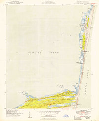
1950 Map of Buxton
USGS Topo · Published 1950About this map
Hatteras Island is captured here as a slender ribbon of sand and marsh, defined by its maritime infrastructure and the narrow boundary between the Pamlico Sound and the Atlantic Ocean. The landscape centers on the fishing and maritime communities of Avon and Buxton, linked by a single road and a telephone line that snakes along the dunes. The map documents a critical period of transition for the Cape, noting both the modern Cape Hatteras Light and the Cape Hatteras Lighthouse (Abnd), alongside the Big Kinnakeet Coast Guard Station which is also marked as abandoned. Inland, the dense vegetation of Buxton Woods contrasts with the surrounding tidal marshes like Jeanette Sedge and Black Hammock, illustrating the varied ecology that has sheltered Outer Banks residents for generations.
Find a feature on this map
38 named features on this map. Tap any name to fly to it.
Don’t see what you’re looking for? This feature index may not catch every label — zoom into the map to look around manually.
Map Details
Editions of this 1950 Buxton Map
2 editions found
Other maps of this area

1948 · Cape Hatteras
USGS Topo · 1:24,000

1948 · Buxton
USGS Topo · 1:24,000

1950 · Cape Hatteras
USGS Topo · 1:24,000

1950 · Buxton
USGS Topo · 1:24,000

1955 · Wanchese
USGS Topo · 1:250,000

1957 · Manteo
USGS Topo · 1:250,000

1960 · Manteo
USGS Topo · 1:250,000

1985 · Cape Hatteras
USGS Topo · 1:100,000

2002 · Cape Hatteras
USGS Topo · 1:24,000

2011 · Buxton
USGS Topo · 1:24,000