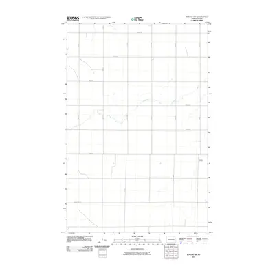
2011 Map of Buxton NW
USGS Topo · Published 2011About this map
Cole Creek meanders through this agricultural landscape in Grand Forks County, providing a natural break in the strictly rectangular grid of the Red River Valley. The terrain is defined by its section-line roads, including 19th St and 14th St, which facilitate the movement of goods across the expansive farmland. This 2011 survey captures the rural infrastructure at a point of modernization, where established thoroughfares like County Hwy-23 and County Hwy-26 intersect the local road network. Near the eastern edge of the quadrangle, Calvary Cemetery serves as a localized landmark for genealogists and historians tracing the families who settled this fertile stretch of North Dakota. The map reflects a landscape dedicated to large-scale cultivation, where the only significant deviations from the cardinal grid are the natural curves of the creek and the occasional township road adjustments.
Find a feature on this map
18 named features on this map. Tap any name to fly to it.
Don’t see what you’re looking for? This feature index may not catch every label — zoom into the map to look around manually.
Map Details
Editions of this 2011 Buxton NW Map
This is the sole edition of this map. No revisions or reprints were ever made.
Other maps of this area

1934 · Emerado
USGS Topo · 1:48,000

1934 · Grand Forks
USGS Topo · 1:62,500

1936 · Emerado
USGS Topo · 1:62,500

1938 · Grand Forks
USGS Topo · 1:62,500

1952 · Grand Forks
USGS Topo · 1:250,000

1956 · Grand Forks
USGS Topo · 1:250,000

1963 · Emerado SE
USGS Topo · 1:24,000

1966 · Grand Forks
USGS Topo · 1:250,000
1970 · Mayville North
USGS Topo · 1:24,000
1971 · Thompson
USGS Topo · 1:24,000