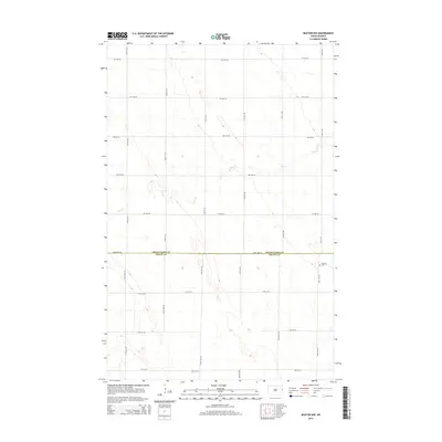
2014 Map of Buxton NW
USGS Topo · Published 2014About this map
The county boundary between Grand Forks Co and Traill Co bisects this Red River Valley landscape, where a rigid grid of agricultural roads defines the terrain. The intermittent flow of Cole Cr meanders across the northern half of the quadrangle, carving subtle depressions in the flat prairie. The most significant historical marker is Calvary Cem, situated in the southeastern corner near 160th Ave NE. The road network, including arterial routes like Eagle Ave NE, reflects the systematic land divisions of North Dakota's farming heartland. This 2014 survey captures the persistence of these rural boundaries and the placement of local landmarks in an area dominated by open fields and agricultural production.
Find a feature on this map
21 named features on this map. Tap any name to fly to it.
Don’t see what you’re looking for? This feature index may not catch every label — zoom into the map to look around manually.
Map Details
Editions of this 2014 Buxton NW Map
This is the sole edition of this map. No revisions or reprints were ever made.
Other maps of this area

1934 · Emerado
USGS Topo · 1:48,000

1934 · Grand Forks
USGS Topo · 1:62,500

1936 · Emerado
USGS Topo · 1:62,500

1938 · Grand Forks
USGS Topo · 1:62,500

1952 · Grand Forks
USGS Topo · 1:250,000

1956 · Grand Forks
USGS Topo · 1:250,000

1963 · Emerado SE
USGS Topo · 1:24,000

1966 · Grand Forks
USGS Topo · 1:250,000
1970 · Mayville North
USGS Topo · 1:24,000
1971 · Thompson
USGS Topo · 1:24,000