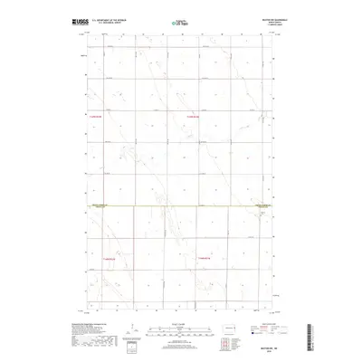
2018 Map of Buxton NW
USGS Topo · Published 2018About this map
The Grand Forks Co Traill Co boundary line divides this agricultural landscape, where the flat Red River Valley terrain is defined by a rigid section-line grid of rural roads. Co Hwy 25 and Co Rd 22 serve as primary east-west arteries for the dispersed farming community. The most significant cultural landmark is Calvary Cem, situated in the southeastern portion of the map near the intersection of 14th St Ne. Natural drainage is limited in this prairie environment, primarily represented by the meandering course of Cole Cr, which winds through the center of the survey. The mapping of township lines like t149n r51w and t148n r51w illustrates the systematic land division essential to North Dakota's agricultural heritage.
Find a feature on this map
24 named features on this map. Tap any name to fly to it.
Don’t see what you’re looking for? This feature index may not catch every label — zoom into the map to look around manually.
Map Details
Editions of this 2018 Buxton NW Map
This is the sole edition of this map. No revisions or reprints were ever made.
Other maps of this area

1934 · Emerado
USGS Topo · 1:48,000

1934 · Grand Forks
USGS Topo · 1:62,500

1936 · Emerado
USGS Topo · 1:62,500

1938 · Grand Forks
USGS Topo · 1:62,500

1952 · Grand Forks
USGS Topo · 1:250,000

1956 · Grand Forks
USGS Topo · 1:250,000

1963 · Emerado SE
USGS Topo · 1:24,000

1966 · Grand Forks
USGS Topo · 1:250,000
1970 · Mayville North
USGS Topo · 1:24,000
1971 · Thompson
USGS Topo · 1:24,000