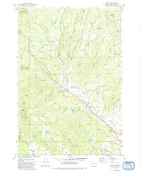
1979 Map of Buxton
USGS Topo · Published 1979About this map
The Southern Pacific railroad corridor serves as the industrial spine of this late-1970s landscape, passing through the rugged terrain of the Tillamook State Forest and the northern reaches of the Tualatin Valley. The settlement of Buxton occupies a central position near the West Fork Dairy Creek, surrounded by numerous topographical landmarks such as Mendenhall Canyon and Eagle Peak.
Find a feature on this map
59 named features on this map. Tap any name to fly to it.
Don’t see what you’re looking for? This feature index may not catch every label — zoom into the map to look around manually.
Map Details
Editions of this 1979 Buxton Map
2 editions found
Other maps of this area

1940 · Vernonia
USGS Topo · 1:62,500

1941 · Keasey
USGS Topo · 1:62,500

1941 · Timber
USGS Topo · 1:62,500

1941 · Gales Creek
USGS Topo · 1:62,500

1943 · Vernonia
USGS Topo · 1:62,500

1943 · Keasey
USGS Topo · 1:62,500

1948 · Vancouver
USGS Topo · 1:250,000

1950 · Vancouver
USGS Topo · 1:250,000

1950 · Vancouver
USGS Topo · 1:250,000

1955 · Timber
USGS Topo · 1:62,500