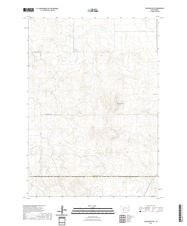
2021 Map of Buzzard Butte
USGS Topo · Published 2021About this map
Buzzard Butte stands as the primary landmark in this section of the western South Dakota plains, situated within the expansive ranchlands of Jackson County. The landscape is defined by the ephemeral drainage patterns of Settin Up Cr in the northern reaches and the headwaters of Buzzard Cr further south. This 2021 survey illustrates the modern rural infrastructure of the region, where gravel access routes like Buzzard Butte Rd and various county section roads including CS 63 provide the only movement across the high prairie. The boundary line for Jackson Co Bennett Co cuts horizontally across the lower third of the quadrangle, marking the transition between jurisdictions. The map captures a largely unpopulated landscape where topographic relief is subtle, save for the prominent rise of the namesake butte, reflecting the enduring character of the Great Plains interior.
Find a feature on this map
18 named features on this map. Tap any name to fly to it.
Don’t see what you’re looking for? This feature index may not catch every label — zoom into the map to look around manually.
Map Details
Editions of this 2021 Buzzard Butte Map
This is the sole edition of this map. No revisions or reprints were ever made.
Other maps of this area

1950 · Wanblee
USGS Topo · 1:24,000

1955 · Martin
USGS Topo · 1:250,000

1958 · Martin
USGS Topo · 1:250,000

1980 · Kadoka
USGS Topo · 1:100,000

1981 · Long Valley
USGS Topo · 1:25,000

1981 · Patricia
USGS Topo · 1:25,000

1981 · Broken Leg Dam
USGS Topo · 1:24,000

1981 · Blackpipe
USGS Topo · 1:25,000
1981 · Short Bow Creek
USGS Topo · 1:25,000
1981 · Buzzard Butte
USGS Topo · 1:25,000