
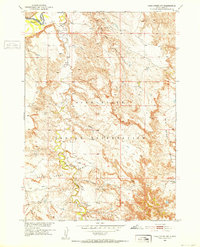
1981 Map of Short Bow Creek
USGS Topo · Published 1981About this map
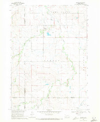
Pine Ridge Indian Reservation lands within Jackson County define this prairie landscape, where the drainage network of the Pass Creek Basin converges. In this 1981 survey, the terrain is characterized by a series of seasonal waterways and springs, including Hooks Spring and Corn Spring, which were vital water sources for ranching and settlement in this semi-arid region. Small-scale water management is evident through various structures like Berry Dam and the Hume Creek Dam. The topographical character is marked by distinctive elevations like Half Dome and the winding course of Short Bow Creek. These features illustrate the sparse, water-dependent settlement patterns common on the reservation during the late twentieth century, before more modern infrastructure altered the rural landscape.
Find a feature on this map
25 named features on this map. Tap any name to fly to it.
Don’t see what you’re looking for? This feature index may not catch every label — zoom into the map to look around manually.
Map Details
Editions of this 1981 Short Bow Creek Map
This is the sole edition of this map. No revisions or reprints were ever made.
Other maps of this area
1951 · Pass Creek NW
USGS Topo · 1:24,000
1951 · Cedar Butte NW
USGS Topo · 1:24,000
1951 · Wanblee NE
USGS Topo · 1:24,000
1951 · Pass Creek NE
USGS Topo · 1:24,000

1955 · Martin
USGS Topo · 1:250,000

1958 · Martin
USGS Topo · 1:250,000
1969 · Norris
USGS Topo · 1:24,000

1980 · Kadoka
USGS Topo · 1:100,000

1981 · Cedar Butte
USGS Topo · 1:25,000

1981 · Long Valley
USGS Topo · 1:25,000