
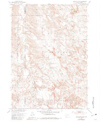
1951 Map of Cedar Butte NW
USGS Topo · Published 1953About this map
Pine Ridge Indian Reservation lands dominate the western portion of this 1951 landscape, where the meandering course of Black Pipe Creek and Cottonwood Creek carve through the high plains. The map captures a moment of remote ranching and spiritual life in the early 1950s, centered around the Walker Ranch and the community hub at Church Creek Ch and its accompanying Church Creek Ch Cem.
Find a feature on this map
17 named features on this map. Tap any name to fly to it.
Don’t see what you’re looking for? This feature index may not catch every label — zoom into the map to look around manually.
Map Details
Editions of this 1951 Cedar Butte NW Map
2 editions found
Other maps of this area

1951 · Stamford SW
USGS Topo · 1:24,000

1951 · Belvidere
USGS Topo · 1:24,000

1951 · Stamford SE
USGS Topo · 1:24,000

1951 · Cedar Butte NE
USGS Topo · 1:24,000

1951 · Pass Creek NE
USGS Topo · 1:24,000

1955 · Martin
USGS Topo · 1:250,000

1958 · Martin
USGS Topo · 1:250,000

1980 · Kadoka
USGS Topo · 1:100,000

1981 · Cedar Butte
USGS Topo · 1:25,000
1981 · Short Bow Creek
USGS Topo · 1:25,000