
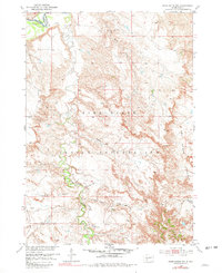
1951 Map of Pass Creek NW
USGS Topo · Published 1952About this map
The Pine Ridge Indian Reservation landscape is defined by the sharp transition between its high ridges and the sprawling river basins of western South Dakota. Along the northern edge, the White River establishes the Reservation Boundary, while the interior is carved by the intricate drainage systems of Pass Creek and its tributaries. The topography reveals the characteristic badlands and prairie breaks of the Pine Ridge upland, dropping steeply into the Red Stone Basin and the Pass Creek Basin. These vast stretches of open country reflect a late mid-century ranching economy, marked by isolated homesteads such as Pettijohn Ranch and Rock Ranch. A small Cem and the presence of scattered water sources like Bowman Pond indicate the sparse but established human footprint within this rugged geography of the early 1950s.
Find a feature on this map
16 named features on this map. Tap any name to fly to it.
Don’t see what you’re looking for? This feature index may not catch every label — zoom into the map to look around manually.
Map Details
Editions of this 1951 Pass Creek NW Map
2 editions found
Other maps of this area

1951 · Belvidere
USGS Topo · 1:24,000

1951 · Kadoka
USGS Topo · 1:24,000

1951 · Belvidere SW
USGS Topo · 1:24,000

1951 · Wanblee NE
USGS Topo · 1:24,000

1951 · Pass Creek NE
USGS Topo · 1:24,000

1955 · Martin
USGS Topo · 1:250,000

1958 · Martin
USGS Topo · 1:250,000

1980 · Kadoka
USGS Topo · 1:100,000

1981 · Broken Leg Dam
USGS Topo · 1:24,000
1981 · Short Bow Creek
USGS Topo · 1:25,000