
1951 Map of Belvidere SW
USGS Topo · Published 1952About this map
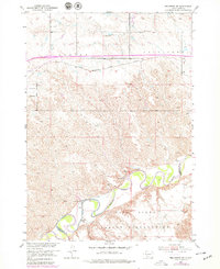
The White River carves a complex, meandering path across the southern portion of this landscape, marking the northern boundary of the Pine Ridge Indian Reservation. This 1951 field check reveals a frontier-style settlement pattern defined by isolated family operations such as the Word Ranch, Smith Ranch, and Youman Ranch. The northern half of the map is dominated by the strategic corridor of the Chicago Milwaukee St Paul and Pacific railroad, which runs east-west across a series of high ridges and drainage divides.
Find a feature on this map
15 named features on this map. Tap any name to fly to it.
Don’t see what you’re looking for? This feature index may not catch every label — zoom into the map to look around manually.
Map Details
Editions of this 1951 Belvidere SW Map
2 editions found
Other maps of this area

1951 · Pass Creek NW
USGS Topo · 1:24,000

1951 · Belvidere
USGS Topo · 1:24,000

1951 · Kadoka
USGS Topo · 1:24,000

1951 · Wanblee NE
USGS Topo · 1:24,000

1951 · Pass Creek NE
USGS Topo · 1:24,000

1953 · Belvidere NE
USGS Topo · 1:24,000

1954 · Belvidere NW
USGS Topo · 1:24,000

1954 · Kadoka NE
USGS Topo · 1:24,000

1955 · Martin
USGS Topo · 1:250,000

1958 · Martin
USGS Topo · 1:250,000