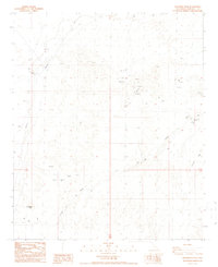
1988 Map of Buzzards Peak
USGS Topo · Published 1988About this map
Buzzards Peak dominates this arid landscape in eastern Imperial County, where 1980s surveyors documented a terrain defined by desert drainage and resource extraction. The area is characterized by a network of ephemeral watercourses, most notably Vinagre Wash and the broad area of Gold Basin. Evidence of small-scale mining and prospecting is scattered throughout the township, with numerous Prospects and individual Mines dotting the ridges and desert floor. The small outpost of Midway Well sits along the western edge, serving as a critical waypoint near the Trans Line. To the east, Arrowweed Springs provides a rare water reference point in an otherwise parched environment. This survey captures a moment in the late 20th century before significant modern alterations, showing the traditional relationship between water sources and travel routes in the California desert.
Find a feature on this map
13 named features on this map. Tap any name to fly to it.
Don’t see what you’re looking for? This feature index may not catch every label — zoom into the map to look around manually.
Map Details
Editions of this 1988 Buzzards Peak Map
2 editions found
Other maps of this area

1942 · Blythe
USGS Topo · 1:250,000

1945 · Cibola
USGS Topo · 1:62,500

1945 · Picacho
USGS Topo · 1:62,500

1951 · Picacho
USGS Topo · 1:62,500

1951 · Cibola
USGS Topo · 1:62,500

1953 · Palo Verde Mountains
USGS Topo · 1:62,500

1953 · Quartz Peak
USGS Topo · 1:62,500

1954 · Salton Sea
USGS Topo · 1:250,000
1954 · Picacho NW
USGS Topo · 1:24,000
1954 · Picacho SW
USGS Topo · 1:24,000