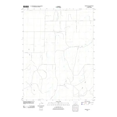
2010 Map of Byers SW
USGS Topo · Published 2010About this map
Rattlesnake Creek meanders northward through the heart of this rural landscape, carving a primary drainage path through the eastern plains of Colorado. This 2010 U.S. Geological Survey representation reveals a classic high-plains settlement pattern, where an orderly grid of county roads defines property boundaries and transport routes across the open terrain. The topography is subtly shaped by several ephemeral waterways, including Mule Gulch to the west and the converging Hay Gulch and Willow Gulch in the southeast. Named corridors such as Woodis Rd and Knudtson Rd serve the sparse residential clusters and agricultural operations. The map provides a clear look at the intersection of early 21st-century rural infrastructure and the natural hydraulic features that have historically influenced the layout of Arapahoe County, Colorado.
Find a feature on this map
26 named features on this map. Tap any name to fly to it.
Don’t see what you’re looking for? This feature index may not catch every label — zoom into the map to look around manually.
Map Details
Editions of this 2010 Byers SW Map
This is the sole edition of this map. No revisions or reprints were ever made.
Other maps of this area

1953 · Denver
USGS Topo · 1:250,000

1955 · Strasburg
USGS Topo · 1:24,000

1956 · Peoria
USGS Topo · 1:24,000

1956 · Byers
USGS Topo · 1:24,000

1957 · Denver
USGS Topo · 1:250,000

1958 · Denver
USGS Topo · 1:250,000

1960 · Denver
USGS Topo · 1:250,000

1968 · Deer Trail
USGS Topo · 1:24,000
1969 · Strasburg SE
USGS Topo · 1:24,000
1969 · Deer Trail
USGS Topo · 1:24,000