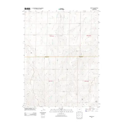
2013 Map of Byers SW
USGS Topo · Published 2013About this map
Rattlesnake Cr winds through the heart of this high plains landscape, defining the drainage patterns across a rural stretch of the Colorado interior. The terrain is deeply articulated by several prominent gulches, including Mule Gulch, Hay Gulch, and Willow Gulch, which break the upland plateaus. This 2013 survey illustrates the boundary between Arapahoe and Elbert counties, showing how modern county roads like CO Road 50 and CO Road 34 follow the rigid lines of the Public Land Survey System. While residential developments are visible near S Kings Valley Ct and E Briarwood Pl, the primary character of the land remains agricultural and open, with long stretches of road such as Behrens Rd and Woods Rd connecting remote properties. Near the southeastern corner, Station Gulch provides a further topographical landmark in this transition between county jurisdictions.
Find a feature on this map
30 named features on this map. Tap any name to fly to it.
Don’t see what you’re looking for? This feature index may not catch every label — zoom into the map to look around manually.
Map Details
Editions of this 2013 Byers SW Map
This is the sole edition of this map. No revisions or reprints were ever made.
Other maps of this area

1953 · Denver
USGS Topo · 1:250,000

1955 · Strasburg
USGS Topo · 1:24,000

1956 · Peoria
USGS Topo · 1:24,000

1956 · Byers
USGS Topo · 1:24,000

1957 · Denver
USGS Topo · 1:250,000

1958 · Denver
USGS Topo · 1:250,000

1960 · Denver
USGS Topo · 1:250,000

1968 · Deer Trail
USGS Topo · 1:24,000
1969 · Strasburg SE
USGS Topo · 1:24,000
1969 · Deer Trail
USGS Topo · 1:24,000