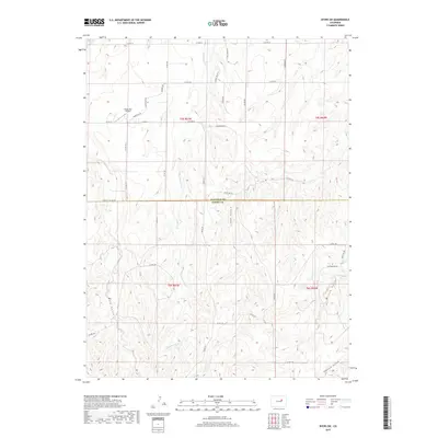
2019 Map of Byers SW
USGS Topo · Published 2019About this map
Arapahoe Co and Elbert Co meet in this high plains landscape defined by a complex network of seasonal drainage channels and remote rural access roads. The north-south flow of Rattlesnake Cr serves as the primary hydrological feature, cutting through terrain marked by deep topographic depressions such as Hay Gulch, Mule Gulch, and Willow Gulch. One of the most distinctive human-made landmarks is the uniquely named Happy Butt Airport, situated along Knudtson Rd in the northern portion of the quadrangle. The map documents a sparse, agricultural settlement pattern where the section-line grid is clearly reflected in the road network, including the prominent Co Line Rd which bisects the territory. This 2019 survey provides researchers with a clear view of the modern land divisions and rural infrastructure across these two Colorado counties.
Find a feature on this map
42 named features on this map. Tap any name to fly to it.
Don’t see what you’re looking for? This feature index may not catch every label — zoom into the map to look around manually.
Map Details
Editions of this 2019 Byers SW Map
This is the sole edition of this map. No revisions or reprints were ever made.
Other maps of this area

1953 · Denver
USGS Topo · 1:250,000

1955 · Strasburg
USGS Topo · 1:24,000

1956 · Peoria
USGS Topo · 1:24,000

1956 · Byers
USGS Topo · 1:24,000

1957 · Denver
USGS Topo · 1:250,000

1958 · Denver
USGS Topo · 1:250,000

1960 · Denver
USGS Topo · 1:250,000

1968 · Deer Trail
USGS Topo · 1:24,000
1969 · Strasburg SE
USGS Topo · 1:24,000
1969 · Deer Trail
USGS Topo · 1:24,000