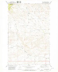
1978 Map of Byrne Creek
USGS Topo · Published 1979About this map
The Highwood Mountains dominate the northwestern corner of this landscape, where the Lewis and Clark National Forest boundary meets the open ranching country of Judith Basin County. The terrain is defined by a dense network of coulees and creeks, including Byrne Creek, Big Arrow Creek, and Hay Creek, which carve through the high plains. Small-scale human activity is visible in the isolated settlements of Knutson and Meyers, while the lower portion of the map traces the path of the Burlington Northern railroad as it skirts the foothills near Geyser. Local history is grounded in specific family-named landmarks like McLeish Cem and the Geyser Cemetery, alongside distinctive geological formations such as Black Buttes and the peak of Spion Kop. The map captures a transition from protected mountain forest to the structured grid of Montana's agricultural and transit corridors.
Find a feature on this map
29 named features on this map. Tap any name to fly to it.
Don’t see what you’re looking for? This feature index may not catch every label — zoom into the map to look around manually.
Map Details
Editions of this 1978 Byrne Creek Map
This is the sole edition of this map. No revisions or reprints were ever made.
Other maps of this area

1890 · Fort Benton
USGS Topo · 1:250,000

1892 · Fort Benton
USGS Topo · 1:250,000

1897 · Fort Benton
USGS Topo · 1:250,000

1954 · Great Falls
USGS Topo · 1:250,000

1957 · Great Falls
USGS Topo · 1:250,000
1961 · The Arch
USGS Topo · 1:24,000
1961 · Limestone Butte
USGS Topo · 1:24,000

1961 · Barker
USGS Topo · 1:62,500

1978 · Arrow Peak
USGS Topo · 1:24,000
1979 · Palisade Butte
USGS Topo · 1:24,000