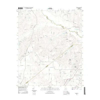
2014 Map of Byron
USGS Topo · Published 2014About this map
The borders of Bibb, Crawford, and Peach Counties converge in this Georgia landscape, dominated by the winding course of Echeconnee Creek and its southern tributaries. The area around Byron and Alpine Heights shows a mix of suburban growth and rural heritage, where modern residential developments like Hidden Forest sit just miles from long-standing family landmarks. Genealogists will find a wealth of specific burial sites scattered across the terrain, from the Waldron Cem in the northeast to the Arnold Mason Cem and Atwaters Cem near the center. The landscape is carved by numerous waterways including Juniper Cr, Mule Cr, and Deep Cr, which historically dictated the placement of roads like Marshall Mill Rd and Taylors Mill Rd. These thoroughfares connect small communities such as Friendship and provide access to local infrastructure like the Hutto Farm Airport.
Find a feature on this map
150 named features on this map. Tap any name to fly to it.
Don’t see what you’re looking for? This feature index may not catch every label — zoom into the map to look around manually.
Map Details
Editions of this 2014 Byron Map
This is the sole edition of this map. No revisions or reprints were ever made.
Other maps of this area

1956 · Fort Valley
USGS Topo · 1:62,500

1956 · Bolingbroke
USGS Topo · 1:62,500

1956 · Warner Robins
USGS Topo · 1:62,500

1956 · Macon West
USGS Topo · 1:24,000

1956 · Macon
USGS Topo · 1:62,500

1957 · Macon
USGS Topo · 1:250,000

1958 · Macon
USGS Topo · 1:250,000

1964 · Macon
USGS Topo · 1:250,000
1973 · Fort Valley West
USGS Topo · 1:24,000
1973 · Warner Robins SW
USGS Topo · 1:24,000