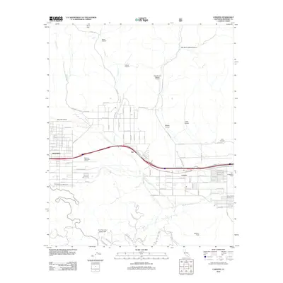
2012 Map of Cabazon
USGS Topo · Published 2012About this map
The San Gorgonio Pass serves as a critical geographic gateway, illustrated here during a period of modern infrastructure development. The settlement of Cabazon occupies the floor of this narrow corridor, while the city of Banning expands along the western edge near the Banning Municipal Airport. The landscape is defined by the braided channels of the San Gorgonio River and numerous drainage systems like Potrero Cr and Hathaway Cr that descend from the surrounding highlands. Evidence of mountain infrastructure is visible at the East Portal Adit and the Barker Peak Lookout, which surveys the high ground near Barker Peak. Between the primary towns, the small siding of Owl sits along the transportation spine. North of the developed corridor, the terrain transitions into complex canyon systems including Millard Canyon and Wood Canyon.
Find a feature on this map
90 named features on this map. Tap any name to fly to it.
Don’t see what you’re looking for? This feature index may not catch every label — zoom into the map to look around manually.
Map Details
Editions of this 2012 Cabazon Map
This is the sole edition of this map. No revisions or reprints were ever made.
Other maps of this area

1901 · Southern California Sheet No. 1
USGS Topo · 1:250,000

1901 · San Jacinto
USGS Topo · 1:125,000

1902 · San Gorgonio
USGS Topo · 1:125,000

1904 · Southern California Sheet No. 1
USGS Topo · 1:250,000

1940 · Palm Springs
USGS Topo · 1:62,500

1942 · Banning
USGS Topo · 1:62,500

1943 · Banning
USGS Topo · 1:62,500

1944 · Palm Springs
USGS Topo · 1:62,500

1947 · Santa Ana
USGS Topo · 1:250,000

1949 · Santa Ana
USGS Topo · 1:250,000