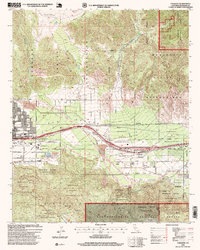
1996 Map of Cabazon
USGS Topo · Published 1999About this map
Morongo Indian Reservation lands dominate the San Gorgonio Pass in this late-twentieth-century study of eastern Banning and the community of Cabazon. The landscape is defined by the critical infrastructure that funnels through this narrow desert corridor, including the Southern Pacific railroad and the massive Colorado River Aqueduct. To the south, the terrain rises sharply toward the San Bernardino National Forest boundary, marked by landmarks like Barker Peak and Cabazon Peak. On the valley floor, the San Gorgonio River bed carves through the pass alongside the Banning Airport. The map documents residential growth in Banning along streets such as E Nicolet St and Ramsey St, while showing the more dispersed settlement patterns of Cabazon near Bonita Ave. Local industry and utility are represented by a Gravel Pit and a Sewage Disposal site, reflecting the region's mid-to-late century development.
Find a feature on this map
36 named features on this map. Tap any name to fly to it.
Don’t see what you’re looking for? This feature index may not catch every label — zoom into the map to look around manually.
Map Details
Editions of this 1996 Cabazon Map
This is the sole edition of this map. No revisions or reprints were ever made.
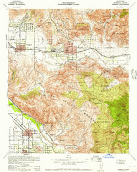
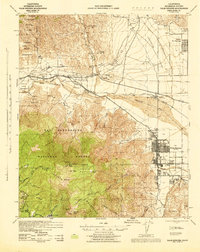
Other maps of this area

1901 · Southern California Sheet No. 1
USGS Topo · 1:250,000

1901 · San Jacinto
USGS Topo · 1:125,000

1902 · San Gorgonio
USGS Topo · 1:125,000

1904 · Southern California Sheet No. 1
USGS Topo · 1:250,000

1940 · Palm Springs
USGS Topo · 1:62,500

1942 · Banning
USGS Topo · 1:62,500
1943 · Banning
USGS Topo · 1:62,500
1944 · Palm Springs
USGS Topo · 1:62,500

1947 · Santa Ana
USGS Topo · 1:250,000

1949 · Santa Ana
USGS Topo · 1:250,000