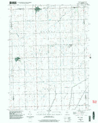
1998 Map of Cabery
USGS Topo · Published 2003About this map
The village of Cabery straddles the line between Ford and Kankakee counties, serving as a primary focal point for this agrarian landscape in the late 1990s. The region is defined by a systematic drainage network including Crane Creek and the West Branch Horse Creek, which navigate the low-lying terrain of Rogers and Mona townships. Near the southern edge of the map, the settlement of Kempton appears with its local Cemetery, while the intentional community of Stelle is visible to the east. The map records several legacy burial sites such as Mount Hope Cem and Floridale Cem, essential for genealogists tracing families in the Illinois prairie. Civil engineering features like the Spoil Bank along Kelly Creek reflect the long-term management of the land for agricultural productivity, a character that persists across the neighboring Milks Grove and Sullivan districts.
Find a feature on this map
23 named features on this map. Tap any name to fly to it.
Don’t see what you’re looking for? This feature index may not catch every label — zoom into the map to look around manually.
Map Details
Editions of this 1998 Cabery Map
This is the sole edition of this map. No revisions or reprints were ever made.
Other maps of this area

1923 · Herscher
USGS Topo · 1:62,500

1925 · Herscher
USGS Topo · 1:62,500

1944 · Piper City
USGS Topo · 1:48,000

1947 · Piper City
USGS Topo · 1:62,500

1947 · Cullom
USGS Topo · 1:62,500

1948 · Dwight
USGS Topo · 1:62,500

1949 · Cullom
USGS Topo · 1:62,500

1950 · Dwight
USGS Topo · 1:62,500

1958 · Aurora
USGS Topo · 1:250,000

1958 · Peoria
USGS Topo · 1:250,000