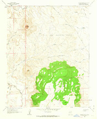
1961 Map of Cabezon Peak
USGS Topo · Published 1963About this map
Cabezon Peak dominates the northern skyline of this 1961 New Mexico landscape, standing as a prominent landmark in the high desert of Sandoval County. The terrain is defined by the massive plateau of Mesa Prieta, which occupies much of the southern half of the sheet, and the winding course of the Rio Puerco to the west. Human presence is concentrated near the river at Casa Salazar, where the Casa Salazar Sch served the local community. The map reveals an intricate network of water management features, including Cabezon Tank No 1 and Canada Bonita Tank, essential for survival in the arid Ojo Del Espiritu Santo grant lands. These features, along with numerous drainage systems like Arroyo Alamo and Arroyo Corrales, illustrate the historical reliance on seasonal water sources in this volcanic and sedimentary terrain.
Find a feature on this map
24 named features on this map. Tap any name to fly to it.
Don’t see what you’re looking for? This feature index may not catch every label — zoom into the map to look around manually.
Map Details
Editions of this 1961 Cabezon Peak Map
2 editions found
Other maps of this area

1883 · Mt. Taylor
USGS Topo · 1:250,000

1886 · Mt. Taylor
USGS Topo · 1:250,000

1888 · Bernalillo
USGS Topo · 1:125,000

1889 · Albuquerque
USGS Topo · 1:125,000

1890 · Jemes
USGS Topo · 1:125,000

1892 · Jemes
USGS Topo · 1:125,000

1892 · Mt. Taylor
USGS Topo · 1:250,000

1893 · Albuquerque
USGS Topo · 1:125,000

1899 · Mt. Taylor
USGS Topo · 1:250,000

1939 · San Ysidro
USGS Topo · 1:62,500