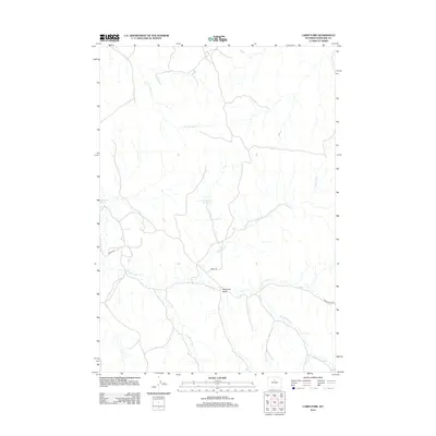
2012 Map of Cabin Fork
USGS Topo · Published 2012About this map
The high desert drainage system of Washakie County is defined here by a network of seasonal forks and draws. Cabin Fork and Hawks Nest Fork converge in a landscape marked by industrial access and water management, notably at the Lyman Reservoir Number 1. This 2012 survey illustrates how the region's ranching and energy infrastructure rely on these intermittent watercourses, including Joe Henry Fork and the E Fork Nowater Cr. Human activity in this arid terrain is evidenced by specialized sites like the Macaroni Pit and the presence of utility roads such as Mobil Rd and Teepee Pole Rd. The geography of Deadman Draw provides a look into the localized naming conventions typical of the Wyoming interior, where every creek, like E Fork Sand Cr, serves as a critical landmark for navigation and land use.
Find a feature on this map
10 named features on this map. Tap any name to fly to it.
Don’t see what you’re looking for? This feature index may not catch every label — zoom into the map to look around manually.
Map Details
Editions of this 2012 Cabin Fork Map
This is the sole edition of this map. No revisions or reprints were ever made.
Other maps of this area

1955 · Sheridan
USGS Topo · 1:250,000

1955 · Arminto
USGS Topo · 1:250,000

1958 · Sheridan
USGS Topo · 1:250,000

1958 · Arminto
USGS Topo · 1:250,000

1962 · Sheridan
USGS Topo · 1:250,000

1962 · Arminto
USGS Topo · 1:250,000

1966 · Deadline Draw
USGS Topo · 1:24,000

1966 · Cabin Fork
USGS Topo · 1:24,000

1966 · Wagon Prong
USGS Topo · 1:24,000
1966 · Henry Draw
USGS Topo · 1:24,000