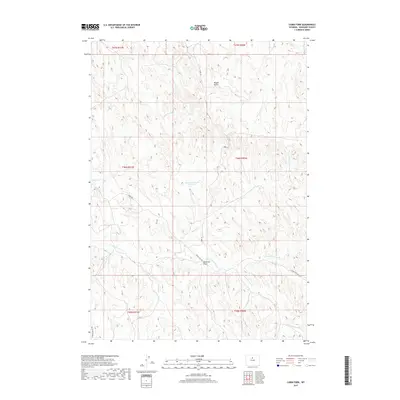
2017 Map of Cabin Fork
USGS Topo · Published 2017About this map
Meyers Gulch and Deadman Draw carve through the high desert landscape of Washakie County, where water management and resource extraction define the human footprint. The Lyman Reservoir Number 1 sits at the center of a complex drainage network that includes the Joe Henry Fork and the namesake Cabin Fork. These waterways, often ephemeral in nature, feed into larger systems like E Fork Nowater Cr, which is tracked by the E Fork Nowater Trl. This area is characterized by its isolation and utility, evident in the industrial presence of the Macaroni Pit and the specialized access provided by Mobil Rd and Teepee Pole Rd. The mapping highlights the township and range survey lines that govern this portion of the Big Horn Basin, revealing how infrastructure follows the natural contours of the gulches and forks.
Find a feature on this map
19 named features on this map. Tap any name to fly to it.
Don’t see what you’re looking for? This feature index may not catch every label — zoom into the map to look around manually.
Map Details
Editions of this 2017 Cabin Fork Map
This is the sole edition of this map. No revisions or reprints were ever made.
Other maps of this area

1955 · Sheridan
USGS Topo · 1:250,000

1955 · Arminto
USGS Topo · 1:250,000

1958 · Sheridan
USGS Topo · 1:250,000

1958 · Arminto
USGS Topo · 1:250,000

1962 · Sheridan
USGS Topo · 1:250,000

1962 · Arminto
USGS Topo · 1:250,000

1966 · Deadline Draw
USGS Topo · 1:24,000

1966 · Cabin Fork
USGS Topo · 1:24,000

1966 · Wagon Prong
USGS Topo · 1:24,000
1966 · Henry Draw
USGS Topo · 1:24,000