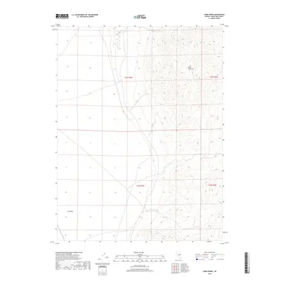
2018 Map of Cabin Spring
USGS Topo · Published 2018About this map
The Butte Mountains dominate the eastern landscape of this high-desert Nevada survey, rising sharply from the floor of Long Valley. This portion of White Pine County showcases a classic Basin and Range environment, where the vast, flat drainage of the valley gives way to the complex topography of the mountain slopes. A critical water source in this arid terrain, Cabin Spring, is located in the southeastern quadrant, providing a vital point of reference for cattle ranchers and land managers in a region defined by its sparse hydrology. The map's layout, organized by the Public Land Survey System through townships like t23n r59e and t23n r60e, highlights the geometric division of the open range against the natural, sinuous contour lines of the mountains.
Find a feature on this map
7 named features on this map. Tap any name to fly to it.
Don’t see what you’re looking for? This feature index may not catch every label — zoom into the map to look around manually.
Map Details
Editions of this 2018 Cabin Spring Map
This is the sole edition of this map. No revisions or reprints were ever made.
Other maps of this area

1956 · Ely
USGS Topo · 1:250,000

1959 · Ely
USGS Topo · 1:250,000

1963 · Ely
USGS Topo · 1:250,000
1982 · Junction Well
USGS Topo · 1:24,000
1982 · Cabin Spring
USGS Topo · 1:24,000

1982 · White Sage Well
USGS Topo · 1:24,000
1982 · McBrides Sheep Well
USGS Topo · 1:24,000
1982 · Long Valley Slough
USGS Topo · 1:24,000
1982 · Cow Camp
USGS Topo · 1:24,000
1982 · Tognini Spring
USGS Topo · 1:24,000