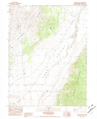
1982 Map of Junction Well
USGS Topo · Published 1982About this map
Maverick Springs Range and the Butte Mountains flank a high desert basin in this White Pine County survey, revealing a landscape defined by scarce water and specialized ranching infrastructure. At the heart of the valley, the Junction Well serves as a primary reference point for travelers and local operations, supported by localized features like Cabin Spring and a Stock Tank. The terrain is characterized by the expansive Long Valley floor, where specialized landforms such as Alkali Flat and Sand Dunes suggest a dynamic environment of seasonal evaporation and wind-driven shifts.
Find a feature on this map
22 named features on this map. Tap any name to fly to it.
Don’t see what you’re looking for? This feature index may not catch every label — zoom into the map to look around manually.
Map Details
Editions of this 1982 Junction Well Map
This is the sole edition of this map. No revisions or reprints were ever made.
Other maps of this area

1955 · Elko
USGS Topo · 1:250,000

1956 · Ely
USGS Topo · 1:250,000

1958 · Elko
USGS Topo · 1:250,000

1959 · Ely
USGS Topo · 1:250,000

1962 · Elko
USGS Topo · 1:250,000

1963 · Ely
USGS Topo · 1:250,000

1965 · Elko
USGS Topo · 1:250,000
1968 · Ruby Lake SE
USGS Topo · 1:24,000
1969 · Station Butte
USGS Topo · 1:24,000
1982 · Cabin Spring
USGS Topo · 1:24,000