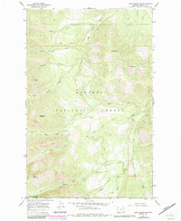
1966 Map of Cable Mountain
USGS Topo · Published 1984About this map
Kootenai National Forest dominates this mountain landscape, which was photogrammetrically mapped in the mid-1960s with revisions following in the early 1980s. The terrain is defined by several prominent peaks, including Cable Mountain and McDonald Mountain, which tower over a network of tributary drainages. Among these are Snowshoe Creek, Big Cherry Creek, and Poorman Creek, names that suggest the area's prospecting history. Near the southeastern corner of the map, Libby Creek flows past Old Town (Site), providing a specific point of interest for those researching early mining era settlements in Lincoln County. Evidence of resource exploration is further cemented by a named Prospect located near Leigh Creek and the southern edge of the Cabinet Mountains Wilderness. The map captures the transition between high alpine ridges and the creek-bottom sites where early inhabitants established their footholds.
Find a feature on this map
28 named features on this map. Tap any name to fly to it.
Don’t see what you’re looking for? This feature index may not catch every label — zoom into the map to look around manually.
Map Details
Editions of this 1966 Cable Mountain Map
2 editions found
Other maps of this area

1920 · Libby
USGS Topo · 1:125,000

1920 · Jennings
USGS Topo · 1:125,000

1930 · Libby
USGS Topo · 1:125,000

1932 · Libby
USGS Topo · 1:125,000

1935 · Thompson Lakes
USGS Topo · 1:96,000

1942 · Thompson Lakes
USGS Topo · 1:125,000

1957 · Kalispell
USGS Topo · 1:250,000

1960 · Kalispell
USGS Topo · 1:250,000

1961 · Kalispell
USGS Topo · 1:250,000

1963 · Swede Mountain
USGS Topo · 1:24,000