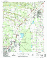
1987 Map of Cabot
USGS Topo · Published 1987About this map
The Pulaski and Lonoke county line divides this mid-1980s landscape, where the growing residential areas of Jacksonville and Cabot meet the expansive wetlands of the Holland Bottoms State Wildlife Management Area. The map reveals a transition from the structured military grounds of Little Rock Air Force Base in the southwest to the rural ridges and bayous further north. Settlement patterns follow the elevated ground of Backbone Ridge and Mill Ridge, with numerous country churches like Mt Pleasant Ch and Ebenezer Ch serving as community anchors.
Find a feature on this map
58 named features on this map. Tap any name to fly to it.
Don’t see what you’re looking for? This feature index may not catch every label — zoom into the map to look around manually.
Map Details
Editions of this 1987 Cabot Map
2 editions found
Other maps of this area

1891 · Little Rock
USGS Topo · 1:125,000

1893 · Little Rock
USGS Topo · 1:125,000

1935 · Mc Almont
USGS Topo · 1:24,000

1940 · Lonoke
USGS Topo · 1:62,500

1941 · Olmstead
USGS Topo · 1:31,680

1941 · Cabot
USGS Topo · 1:31,680

1943 · Jacksonville
USGS Topo · 1:31,680

1948 · Helena
USGS Topo · 1:250,000

1949 · Lonoke
USGS Topo · 1:62,500

1950 · Helena
USGS Topo · 1:250,000