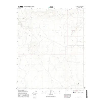
2017 Map of Cabra Hill
USGS Topo · Published 2017About this map
Conchas River meanders across this high plains terrain in San Miguel County, shaping the drainage patterns for several smaller tributaries. This arid landscape is defined by its water sources, with Salitre Cr entering from the north and Cabra Cr flowing through the southern reaches. The most prominent elevation on the sheet is Cabra Hill, which rises above the surrounding flats in the southeastern quadrant. Nearby, Cabra Springs provides a critical point of interest in a region primarily used for large-scale ranching and land management. The map also delineates the t13n r22e township and range boundaries, reflecting the enduring Public Land Survey System that governs this section of New Mexico.
Find a feature on this map
6 named features on this map. Tap any name to fly to it.
Don’t see what you’re looking for? This feature index may not catch every label — zoom into the map to look around manually.
Map Details
Editions of this 2017 Cabra Hill Map
This is the sole edition of this map. No revisions or reprints were ever made.
Other maps of this area

1892 · Corazon
USGS Topo · 1:125,000

1894 · Corazon
USGS Topo · 1:125,000

1954 · Santa Fe
USGS Topo · 1:250,000

1958 · Santa Fe
USGS Topo · 1:250,000

1963 · Cactus Tank
USGS Topo · 1:24,000

1963 · Mesa Cherisco
USGS Topo · 1:24,000
1963 · Horse Pasture Tank
USGS Topo · 1:24,000
1963 · Bar Y Ranch
USGS Topo · 1:24,000

1963 · Flagstone Mountain
USGS Topo · 1:24,000
1972 · Cabra Hill
USGS Topo · 1:24,000