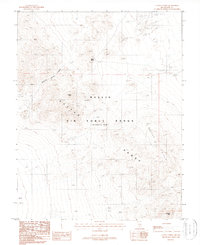
1988 Map of Cactus Spring
USGS Topo · Published 1988About this map
Cactus Spring anchors this high-desert landscape in Nye County, Nevada, where industrial military infrastructure meets historical prospecting. Located within the Nellis Air Force Range (Restricted Area), the terrain is defined by tactical installations such as Radar Hill 24 and Site 24 Radar, alongside a series of numbered targets. These modern markers contrast with older mineral extractions concentrated around Urania Peak. Geologic interests are evident in the Dacite Hills and the winding path of Sleeping Column Canyon. Evidence of early mining persists through the Urania Mine and several scattered prospects and an adit. The map illustrates the specialized mid-to-late 20th-century use of the Nevada desert, where remote mountains like Antelope Peak became essential for both mineral exploration and advanced aerospace testing.
Find a feature on this map
21 named features on this map. Tap any name to fly to it.
Don’t see what you’re looking for? This feature index may not catch every label — zoom into the map to look around manually.
Map Details
Editions of this 1988 Cactus Spring Map
This is the sole edition of this map. No revisions or reprints were ever made.
Other maps of this area

1908 · Kawich
USGS Topo · 1:250,000

1942 · Cactus Range
USGS Topo · 1:125,000

1952 · Stinking Spring
USGS Topo · 1:62,500

1952 · Mellan
USGS Topo · 1:62,500

1952 · Cactus Spring
USGS Topo · 1:62,500

1952 · Cactus Peak
USGS Topo · 1:62,500

1954 · Goldfield
USGS Topo · 1:250,000

1955 · Goldfield
USGS Topo · 1:250,000

1958 · Goldfield
USGS Topo · 1:250,000

1962 · Goldfield
USGS Topo · 1:250,000