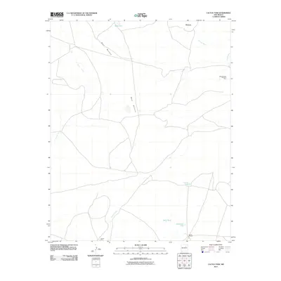
2010 Map of Cactus Tank
USGS Topo · Published 2010About this map
Mesa Montosa dominates the high desert terrain of San Miguel County in this 2010 survey, reflecting a landscape shaped by both natural drainage and ranching infrastructure. The arid environment is marked by an essential network of water features including Cactus Tank, Saxon Tank, and Horsehead Tank, which historically supported livestock in this part of New Mexico. Small settlements like Montosa and Alamito Camp are connected by a web of unimproved roads and 4WD tracks, indicating the remote character of the area during the early 21st century.
Find a feature on this map
12 named features on this map. Tap any name to fly to it.
Don’t see what you’re looking for? This feature index may not catch every label — zoom into the map to look around manually.
Map Details
Editions of this 2010 Cactus Tank Map
This is the sole edition of this map. No revisions or reprints were ever made.
Other maps of this area

1892 · Corazon
USGS Topo · 1:125,000

1894 · Corazon
USGS Topo · 1:125,000

1954 · Santa Fe
USGS Topo · 1:250,000

1958 · Santa Fe
USGS Topo · 1:250,000

1963 · Pedro Miguel Peak
USGS Topo · 1:24,000

1963 · Cactus Tank
USGS Topo · 1:24,000
1963 · Horse Pasture Tank
USGS Topo · 1:24,000
1963 · Bar Y Ranch
USGS Topo · 1:24,000
1963 · Chaperito
USGS Topo · 1:24,000

1963 · Flagstone Mountain
USGS Topo · 1:24,000