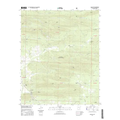
2017 Map of Caddo Gap
USGS Topo · Published 2017About this map
The Caddo River carves through the dramatic ridges of the Ouachita National Forest, defining the landscape at the southern edge of the Crystal Mountains. This 2017 survey details the rural crossroads and mountain gaps of Montgomery County, where small settlements like Caddo Gap and Jones Valley sit along the riverbanks. The high concentration of family and community cemeteries, including Mount Zion Cem, Bassinger Cem, and Nelson Cem, suggests a deep generational attachment to the narrow valleys and hollows. Transportation follows the natural contours of the land, with routes like Stage Coach Rd and Old Caddo Gap Rd tracing historical paths between prominent peaks like White Mtn and Pigeon Roost Mtn. The map captures a topography where timbered ridges and numerous springs, such as Buttermilk Springs and Strawn Springs, remain central to the region's character.
Find a feature on this map
76 named features on this map. Tap any name to fly to it.
Don’t see what you’re looking for? This feature index may not catch every label — zoom into the map to look around manually.
Map Details
Editions of this 2017 Caddo Gap Map
This is the sole edition of this map. No revisions or reprints were ever made.
Other maps of this area

1890 · Mount Ida
USGS Topo · 1:125,000

1890 · Hot Springs
USGS Topo · 1:125,000

1894 · Hot Springs
USGS Topo · 1:125,000

1906 · Caddo Gap
USGS Topo · 1:125,000

1936 · Glenwood
USGS Topo · 1:48,000

1942 · Glenwood
USGS Topo · 1:62,500

1949 · Glenwood
USGS Topo · 1:62,500

1955 · Little Rock
USGS Topo · 1:250,000

1956 · Little Rock
USGS Topo · 1:250,000

1959 · Mount Ida
USGS Topo · 1:62,500