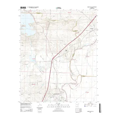
2014 Map of Caddo Valley
USGS Topo · Published 2014About this map
Arkadelphia anchors the southern edge of this Clark County landscape, where the academic campuses of Henderson State Univ and Ouachita Baptist Univ overlook the winding Ouachita River. This modern survey illustrates the complex water management systems of the region, from the massive De Gray Lake in the northwest to the Degray Reregulating Lake and smaller bodies like Country Club Lake. The terrain is defined by the convergence of several major waterways, including the Caddo River and De Roche Creek, which carve through the ridges toward the county line.
Find a feature on this map
113 named features on this map. Tap any name to fly to it.
Don’t see what you’re looking for? This feature index may not catch every label — zoom into the map to look around manually.
Map Details
Editions of this 2014 Caddo Valley Map
This is the sole edition of this map. No revisions or reprints were ever made.
Other maps of this area

1948 · Malvern
USGS Topo · 1:62,500

1949 · Malvern
USGS Topo · 1:62,500

1955 · Little Rock
USGS Topo · 1:250,000

1956 · Little Rock
USGS Topo · 1:250,000

1959 · Caddo Valley
USGS Topo · 1:24,000

1959 · Arkadelphia
USGS Topo · 1:24,000

1960 · Little Rock
USGS Topo · 1:250,000

1964 · Little Rock
USGS Topo · 1:250,000

1964 · Donaldson
USGS Topo · 1:24,000
1965 · Dalark
USGS Topo · 1:24,000