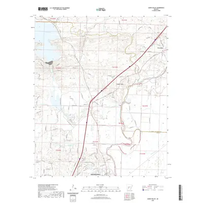
2020 Map of Caddo Valley
USGS Topo · Published 2020About this map
Arkadelphia anchors the southern portion of this landscape, home to the campus of Henderson State University and several local landmarks including Arkadelphia Cem and Edwards Cem. The terrain is defined by the convergence of the Ouachita River and the Caddo River, which flow through the center and east. To the north, the community of Caddo Valley sits near the junction of major transit routes, while Friendship occupies the northeastern corner. Significant water features like De Gray Lake and Little De Gray Cr highlight the hydrologic importance of the area. The topography rises toward Iron Mountain in the west, creating a diverse geographic profile that includes low-lying areas like Saline Bayou and Tupelo Cr in the southeast. Historical road traces such as Old Military Rd and Old Caddo Trl provide insight into early transportation corridors through Clark County.
Find a feature on this map
127 named features on this map. Tap any name to fly to it.
Don’t see what you’re looking for? This feature index may not catch every label — zoom into the map to look around manually.
Map Details
Editions of this 2020 Caddo Valley Map
This is the sole edition of this map. No revisions or reprints were ever made.
Other maps of this area

1948 · Malvern
USGS Topo · 1:62,500

1949 · Malvern
USGS Topo · 1:62,500

1955 · Little Rock
USGS Topo · 1:250,000

1956 · Little Rock
USGS Topo · 1:250,000

1959 · Caddo Valley
USGS Topo · 1:24,000

1959 · Arkadelphia
USGS Topo · 1:24,000

1960 · Little Rock
USGS Topo · 1:250,000

1964 · Little Rock
USGS Topo · 1:250,000

1964 · Donaldson
USGS Topo · 1:24,000
1965 · Dalark
USGS Topo · 1:24,000