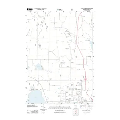
2012 Map of Cadillac North
USGS Topo · Published 2012About this map
Lake Mitchell and Lake Cadillac anchor the southern portion of this region, where the urban expansion of the county seat meets the dense woodlands of the north. The infrastructure of the early 21st century is well-defined, showing the Wexford County Airport and the campus of Baker College of Cadillac near the Clam River. This period shows a transition from the commercial corridors near the Northern District Fairgrounds to the more rural north, where older place names like Missaukee Junction and Haring persist alongside recreational sites like Bond Mill Pond. Local history is preserved at the Haring Township Cem, while the road network, featuring names like Rollaway Trl and Bunkhouse Ln, hints at the area's logging heritage. The map documents the layout of residential streets and forest service access points just before the mid-2010s.
Find a feature on this map
87 named features on this map. Tap any name to fly to it.
Don’t see what you’re looking for? This feature index may not catch every label — zoom into the map to look around manually.
Map Details
Editions of this 2012 Cadillac North Map
This is the sole edition of this map. No revisions or reprints were ever made.
Other maps of this area

1954 · Traverse City
USGS Topo · 1:250,000

1956 · Mesick
USGS Topo · 1:62,500

1956 · Cadillac North
USGS Topo · 1:62,500

1957 · Cadillac South
USGS Topo · 1:62,500

1957 · Luther
USGS Topo · 1:62,500

1958 · Traverse City
USGS Topo · 1:250,000

1983 · Cadillac
USGS Topo · 1:100,000

1983 · Manton
USGS Topo · 1:25,000

1983 · Cadillac North
USGS Topo · 1:24,000
1983 · Cadillac South
USGS Topo · 1:25,000
Featured Places
- Cadillac, MI
- Haring Charter Township, Haring Township
- Haring Township, MI
- Selma Township, MI
- Colfax Township, MI