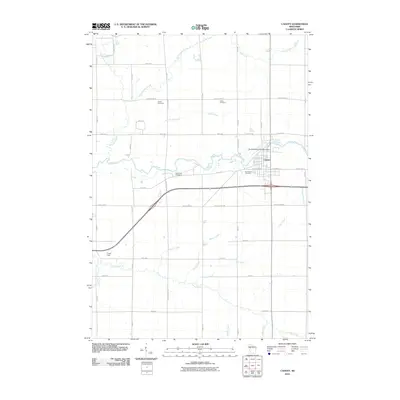
2010 Map of Cadott
USGS Topo · Published 2010About this map
Cadott serves as the primary hub of this landscape, situated at the confluence of the Yellow River and the industrial legacy of the Svetlik Milling Company Dam. The town's layout is well-defined by central thoroughfares like W Chippewa St and E Chippewa St, surrounded by a network of drainage systems including Big Drywood Creek and Dutch Creek. Local history is deeply embedded in the rural surroundings, marked by a high concentration of burial grounds such as Union Cemetery, Goetz Cemetery, and Brooklawn Cemetery. The southern reaches are characterized by broad agricultural fields and intersecting waterways like Clear Creek and Paint Creek, while Crane Field provides a distinct landmark in the southwest. The geography is tied together by an extensive grid of numbered roads and county highways, illustrating the organized rural development of central Wisconsin.
Find a feature on this map
47 named features on this map. Tap any name to fly to it.
Don’t see what you’re looking for? This feature index may not catch every label — zoom into the map to look around manually.
Map Details
Editions of this 2010 Cadott Map
This is the sole edition of this map. No revisions or reprints were ever made.
Other maps of this area

1934 · Chippewa Falls
USGS Topo · 1:62,500

1936 · Chippewa Falls
USGS Topo · 1:62,500

1949 · Bloomer
USGS Topo · 1:62,500

1951 · Bloomer
USGS Topo · 1:62,500

1951 · Cornell
USGS Topo · 1:62,500

1952 · Cadott
USGS Topo · 1:62,500

1953 · Eau Claire
USGS Topo · 1:250,000

1953 · Rice Lake
USGS Topo · 1:250,000

1958 · Eau Claire
USGS Topo · 1:250,000

1959 · Rice Lake
USGS Topo · 1:250,000