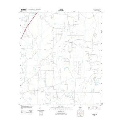
2012 Map of Caesar
USGS Topo · Published 2012About this map
Catahoula Cr and E Hobolochitto Cr define the hydrological character of this South Mississippi landscape, where a network of named branches and creeks drains the wooded terrain near the Hancock and Pearl River county lines. The settlement patterns at Caesar and Leetown reflect a community organized around family-named landmarks and historical homesteads. Evidence of local lineage is found at the Pearson Cem and Gipson Cem, while the landscape is further marked by features such as Lees Field and the waters of Lee Lake. Modern recreational land use is represented by the Clearwater Campground and Recreational Vehicle Park, situated amidst a dense grid of rural roads like Siler Ln and Verna Roche Dr. The map provides a detailed view of the drainage basin, including uniquely named waterways like Dead Tiger Cr and Boardpile Br.
Find a feature on this map
173 named features on this map. Tap any name to fly to it.
Don’t see what you’re looking for? This feature index may not catch every label — zoom into the map to look around manually.
Map Details
Editions of this 2012 Caesar Map
This is the sole edition of this map. No revisions or reprints were ever made.
Other maps of this area

1914 · Nicholson
USGS Topo · 1:62,500

1921 · Nicholson
USGS Topo · 1:62,500

1941 · Honey Island
USGS Topo · 1:31,680

1953 · Mobile
USGS Topo · 1:250,000

1955 · Savannah
USGS Topo · 1:62,500

1955 · Nicholson
USGS Topo · 1:24,000

1957 · Mobile
USGS Topo · 1:250,000

1957 · Dead Tiger Creek
USGS Topo · 1:24,000

1958 · Picayune
USGS Topo · 1:62,500
1959 · Kiln
USGS Topo · 1:24,000