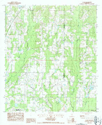
1986 Map of Caesar
USGS Topo · Published 1986About this map
The boundary between Pearl River and Hancock counties divides this landscape of winding southern Mississippi waterways and small rural outposts. The settlement of Caesar serves as a local anchor in the north, while the area is defined by an intricate network of drainage including Hobolochitto Creek and Catahoula Creek. These creeks are fed by numerous family-named and descriptive tributaries like Blacksnake Branch, Boardpile Branch, and Dead Tiger Creek, suggesting a history of local land-use and timbering long before this mid-1980s survey.
Find a feature on this map
20 named features on this map. Tap any name to fly to it.
Don’t see what you’re looking for? This feature index may not catch every label — zoom into the map to look around manually.
Map Details
Editions of this 1986 Caesar Map
This is the sole edition of this map. No revisions or reprints were ever made.
Other maps of this area

1914 · Nicholson
USGS Topo · 1:62,500

1921 · Nicholson
USGS Topo · 1:62,500

1941 · Honey Island
USGS Topo · 1:31,680

1953 · Mobile
USGS Topo · 1:250,000

1955 · Savannah
USGS Topo · 1:62,500

1955 · Nicholson
USGS Topo · 1:24,000

1957 · Mobile
USGS Topo · 1:250,000

1957 · Dead Tiger Creek
USGS Topo · 1:24,000

1958 · Picayune
USGS Topo · 1:62,500
1959 · Kiln
USGS Topo · 1:24,000