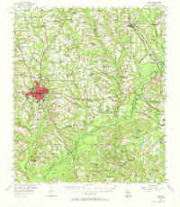
1956 Map of Cairo
USGS Topo · Published 1972About this map
Cairo and Thomasville anchor this mid-century view of the Georgia coastal plain, where the landscape is defined by the winding Ochlocknee River and a dense network of rural communities. The Atlantic Coast Line Railroad corridors facilitate the movement of goods through settlements like Ochlocknee, Pine Park, and Dawesville. The map captures an era of active industry and community life, evidenced by the Silica Sand Mines and dozens of country churches such as New Zion Ch and Pleasant Grove Ch.
Find a feature on this map
79 named features on this map. Tap any name to fly to it.
Don’t see what you’re looking for? This feature index may not catch every label — zoom into the map to look around manually.
Map Details
Editions of this 1956 Cairo Map
2 editions found
Other maps of this area

1953 · Dothan
USGS Topo · 1:250,000

1953 · Waycross
USGS Topo · 1:250,000

1954 · Dothan
USGS Topo · 1:250,000

1954 · Valdosta
USGS Topo · 1:250,000

1954 · Tallahassee
USGS Topo · 1:250,000

1955 · Dothan
USGS Topo · 1:250,000

1955 · Whigham
USGS Topo · 1:62,500

1956 · Cairo
USGS Topo · 1:62,500

1956 · Metcalf
USGS Topo · 1:24,000

1956 · Calvary
USGS Topo · 1:24,000